Bay Area Survey Services for Existing-Condition Risk
Stamped site plan surveys for permit submittals, 3D laser scanning, as-built documentation, scan-based deformation monitoring, condominium conversion scanning, ADA measurement, and difficult boundary surveying for teams that need reliable Bay Area site data.
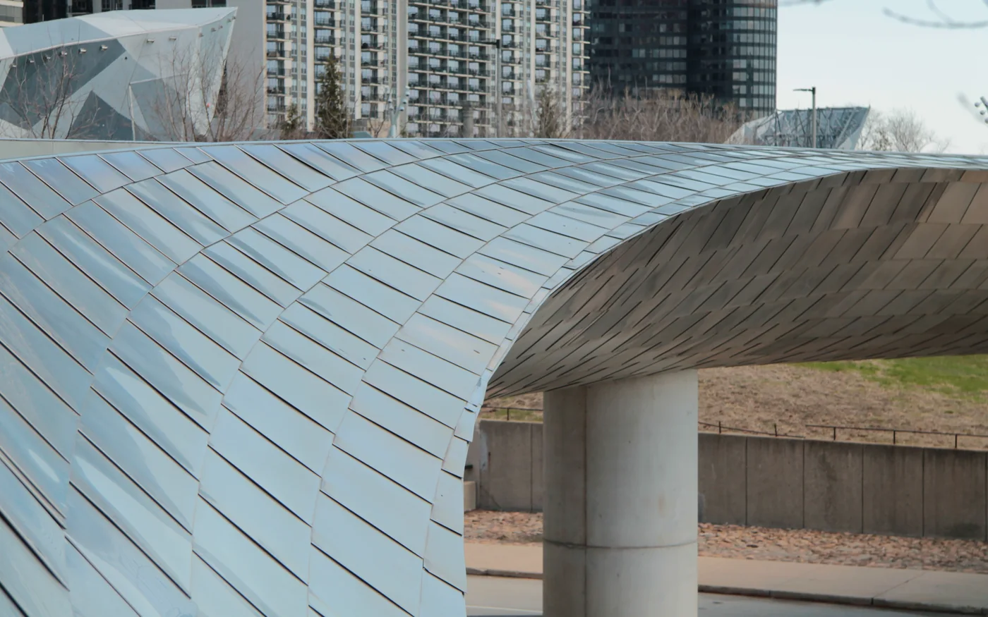
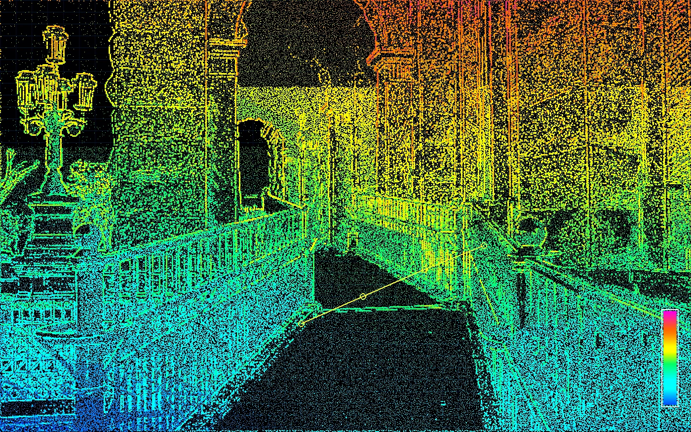
Reality Capture
Point clouds that become usable project files.
High-density scan data supports CAD, BIM-ready modeling, field verification, and existing-condition coordination.
Preservation Record
Digital twins for buildings that do not match old drawings.
Useful for churches, civic buildings, custom structures, facades, sanctuaries, retrofit planning, and archival records.
Built-Condition Proof
Survey-grade measurements for routes, ramps, and transitions.
Document slopes, landings, thresholds, cross-slopes, and site transitions before issues become rework or claims.
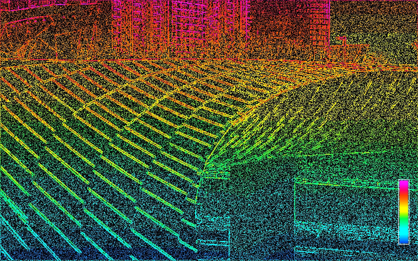
3D Laser Scanning & As-Built Documentation
Capture existing conditions once and give every stakeholder a reliable source of truth. We provide surveyor-led high-density point clouds, CAD drawings, Revit-ready models, and visual 3D deliverables for architects, engineers, contractors, owners, churches, institutions, and preservation teams.
Learn MoreTopographic Surveys & 3D Terrain Mapping
Survey-grade topographic mapping for East Bay and Bay Area properties, captured with a Trimble terrestrial laser scanner (TLS). Where a conventional topo crew records a few hundred shots with a total station, our scanner captures millions of measured points in a single site visit — every grade break, retaining wall, tree, utility feature, and structure — then we extract a clean, CAD-ready base map from the point cloud. The result is a topographic survey your architect or civil engineer can design on without callbacks for missed shots: contours at the interval your project needs, a digital terrain model (DTM), spot elevations, and surface utility features, delivered as DWG/DXF with the underlying point cloud available for the design team. Topographic surveys are required or effectively required for hillside permits, additions and ADUs, grading and drainage design, retaining wall engineering, and most civil site design in Oakland, Berkeley, and surrounding East Bay jurisdictions.
Learn MoreAs-Built Surveys & Scan-to-CAD Documentation
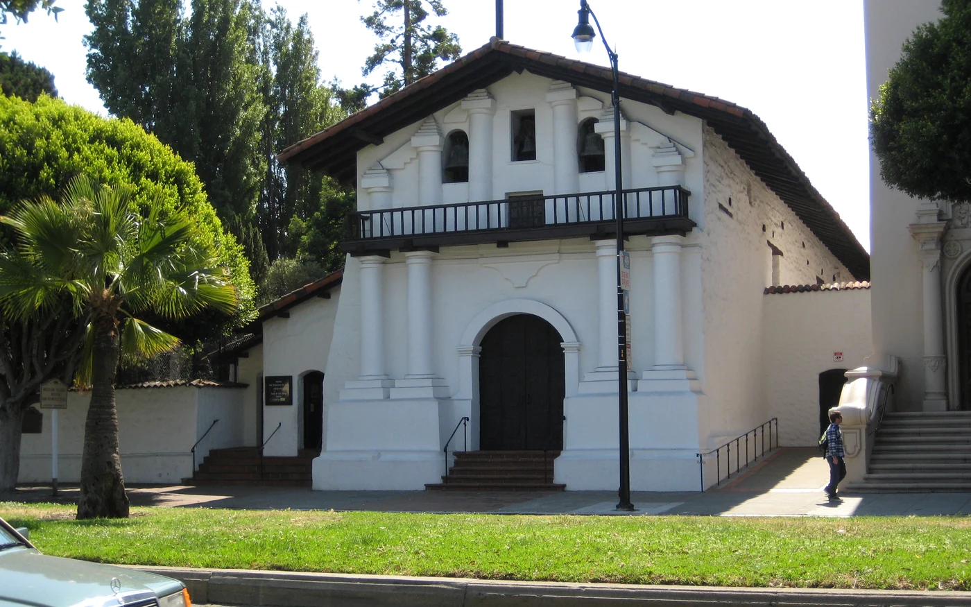
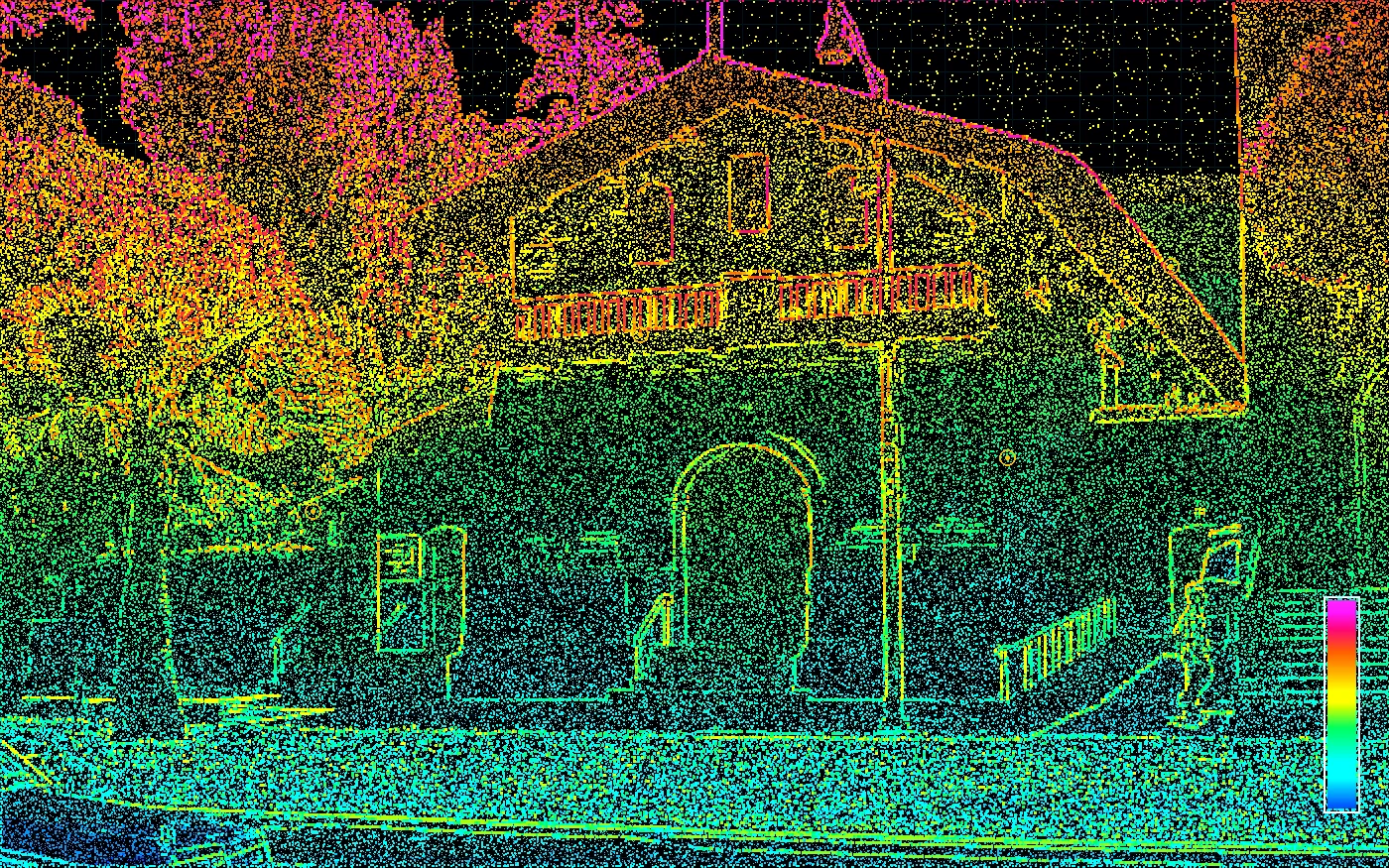
Accurate as-built documentation of existing buildings and sites, captured with a Trimble terrestrial laser scanner and delivered as 2D CAD drawings, Revit models, or registered point clouds. Most East Bay buildings — Victorians, brown-shingles, warehouse conversions, postwar tracts — no longer match their original drawings, if drawings exist at all. Tape-measure and disto as-builts miss out-of-square rooms, sloping floors, and racked walls that laser scanning captures exactly. We scan interiors, facades, and sites in a single visit and produce the existing-conditions documentation architects, structural engineers, and contractors design from: floor plans, reflected ceiling plans, sections, elevations, and BIM-ready Revit models at the level of development your project needs. As-builts are the foundation for remodels, seismic retrofits, condominium conversions, tenant improvements, and facility management.
Learn MoreSite Plan Surveys & Boundary + Topographic Mapping
Stamped site plan surveys, boundary + topographic base maps, and existing-condition documentation for Bay Area permit submittals. Many San Francisco, Oakland, Berkeley, and Peninsula jurisdictions require a site survey wet-stamped by a California Professional Land Surveyor before plans can be submitted, and we deliver CAD-ready base files architects, engineers, and design teams can build on.
Learn MoreBoundary Determination & Difficult Boundary Surveys
Establish clear, legally defensible property boundaries with a licensed Bay Area boundary surveyor — including difficult boundaries on hillside lots, irregular parcels, post-1906 SF blocks, fire-rebuild areas, and properties with conflicting record evidence. We research historical records, locate existing monuments, set durable markers, and prepare Records of Survey or Corner Records when needed for permanent public record protection.
Learn MoreALTA/NSPS Land Title Surveys
Bay Area ALTA/NSPS Land Title Surveys for commercial real estate transactions — built to the 2021 ALTA/NSPS Minimum Standard Detail Requirements and the Table A items your lender, title underwriter, or buyer's counsel requires. We work directly with title officers, CRE attorneys, lenders, brokers, and buyers to deliver a survey the underwriter will accept, on the timeline your closing depends on.
Learn MoreParcel Maps & Lot Line Adjustments
Parcel maps, lot line adjustments, and lot mergers under the California Subdivision Map Act for East Bay property owners and developers. A parcel map is the legal instrument for dividing land into four or fewer parcels — the most common path for splitting a residential lot, carving off a flag lot, or reconfiguring boundaries between neighbors. We handle the complete process: boundary resolution, tentative map preparation, coordination through city and county surveyor review, satisfaction of conditions of approval, and final map recordation with the county recorder. Because we laser-scan the site as part of the fieldwork, the same mobilization produces the topographic base map most jurisdictions require with the tentative map application — one visit, two required products.
Learn MoreMonument Preservation for Construction
Pre-construction monument preservation surveys required by California Business & Professions Code §8771. When grading, paving, utility trenching, or demolition will disturb survey monuments — street monuments, property corners, benchmarks — the law requires that a licensed land surveyor reference them before construction and reset them afterward, with Corner Records filed with the county surveyor both times. Contractors and public agencies are increasingly required to show monument preservation compliance before permits are issued on capital projects, and destroying a monument without preservation exposes the responsible party to the cost of a full retracement survey — far more than preservation would have cost. We locate the monuments in the work zone, set reference ties outside the disturbance area, file the pre-construction Corner Records, and return after construction to reset the monuments and file the post-construction records.
Learn MoreDeformation Monitoring & Scan-Based Movement Surveys
Track structural deformation, settlement, and site movement using a combination of high-density 3D laser scanning and precise survey control. Scan-based monitoring captures full surface geometry over time — not just discrete prism points — so adjacent buildings, slopes, retaining walls, historic structures, and excavation faces can be compared epoch-to-epoch with confidence. In the East Bay hills this includes landslide and slope-creep monitoring: many hillside neighborhoods sit on mapped slow-moving landslides that creep fractions of an inch per year and accelerate in wet winters. Repeat laser-scan epochs compare the entire slope surface — millions of points, not a handful of stakes — detecting millimeter-level movement patterns across the whole hillside before cracks appear in foundations and streets.
Learn MoreCondominium Conversion Surveys & Interior As-Built Scanning
Convert existing buildings into condominium ownership with 3D laser scanning, accurate interior and exterior as-builts, and boundary coordination. Scanning is uniquely suited to condo conversion work — it captures complete unit, common area, and exclusive-use area geometry in a fraction of the field time of hand measurement, and gives developers, architects, attorneys, and HOA teams a reliable record before filings become expensive.
Learn MoreHistoric Preservation & Digital Twin Surveys
Document historic churches, civic buildings, custom homes, and irregular structures without relying on incomplete old drawings. We use 3D laser scanning to capture facades, interiors, structural geometry, and architectural details for restoration, adaptive reuse, and long-term digital archiving.
Learn MoreADA Compliance & Ramp Verification Surveys
Reduce accessibility risk with precise measurements of ramps, landings, routes, slopes, cross-slopes, thresholds, and site transitions. We provide survey-grade documentation that helps architects, engineers, contractors, owners, and counsel evaluate built conditions.
Learn MoreForensic Surveying
Expert investigation and analysis of boundary disputes, encroachments, and property line discrepancies for legal proceedings. Our forensic surveys provide court-admissible evidence and expert witness testimony.
Learn MoreConstruction Staking
Translate design plans into precise field locations for construction. We stake buildings, roads, utilities, and site features ensuring your project is built exactly as designed.
Learn MoreBoundary Dispute Mediation
Resolve property line disagreements professionally with a certified mediator who is also a licensed land surveyor. This rare combination of mediation training and technical surveying expertise means disputes are resolved with both factual precision and structured conflict resolution — without costly litigation.
Learn MoreSubdivisions
Navigate the complex subdivision process with expert guidance. We handle Parcel Maps, Tract Maps, and SB-9 lot splits, managing surveys, mapping, and coordination with local agencies.
Learn MoreFence Surveys
Ensure your fence is built in the right location with a professional property line survey. We locate and mark boundaries before construction to prevent disputes and encroachment issues.
Learn MoreNot Sure Which Service You Need?
Every property and project is unique. Contact us to discuss your situation and we'll recommend the right scanning, as-built, boundary, or documentation path.
Have a Serious Site, Building, or Boundary Problem?
Book a scope meeting with the licensed surveyor. Estimates are prepared for projects with enough context to price responsibly.